About Me

Kuala Lumpur, Malaysia
I am married to my loving husband for more than 45 years now. I am a mother to 3 beautiful children, until years ago when I lost my youngest son. Since then my life is forever altered but yet unbroken....

Monday, 21 September 2015

2015 Pakistan Day 05: Besham - Gilgit

“Climb the mountains and get their good tidings. Nature's peace
will flow into you as sunshine flows into trees…” - John Muir

(The Karakoram Highway)

Day 05: Sunday, 13 September 2015
Route: Besham – Chilas – Gilgit
Distance: 331 km
Hotel: Riveria Hotel

PTDC Motel is overlooking the Indus River with stunning view of the mountain range. It is located at a strategic junction on the road linking the Swat Valley over the Shangla Pass with the Karakoram Highway leading to Gilgit. The motel rooms are spacious and comfortable and the service is excellent. This morning, the sun was not even up yet when we had breakfast of omelettes and toasts.

(The Indus River in the background)

It was a beautiful clear sunny day for driving. The hotel had prepared packed lunch for us. We were informed that it would be difficult to find good restaurants on the way and we may need to have our meal picnic style. It was a long day but the scenery en route more than makes up for it. Following the Silk Route alongside the Indus River, the landscape is spectacular and is getting more rugged as we drove higher up the mountain range.

(A nice view of mountains and rivers)
(Picking wild cannabis by the roadside)

We stopped for lunch in Dassu, a small quiet town that has an altitude of 2,440 m above sea level. The weather was sunny but cool when we eat our packed fried chicken and roti. We had a cup of hot milk tea before we started our onward journey to Chilas.

(A pit stop at a small town of Dassu)
(A busy highway for buses and trucks)
(The unpaved road on the Karakoram Highway)
(The gaudy colored Pakistan lorry)

Today we experienced going through the many police check-points along the Karakoram Highway. According to our local guides, check-points were first set up at troubled areas to ensure safe journey of those using the Karakoram Highway. There were incidences of travelers being fatally shot by miscreants.

(A Police escort in our coaster)
(Rugged terrain along the highway)
(A young Pakistani Policeman as our escort)

Before entering the town of Chilas, at the check point, we had our passports and travel documents checked and scanned. We even had our individual photo taken for their records. From then on we were escorted by an armed police personnel riding in our coaster to the next check-point where he will be replaced by another.

(Meeting Malaysian students in Chilas)

In Chilas we had our prayer break at one of the madrasah where we met with three Malaysian boys who were staying and studying there for a few months.


(A rest after a rough climb to the Petroglyphs Rock)
(An Afghan at the Shatial hanging bridge)

About 60 km from Chilas we stopped in Shatial, the Ancient Silk Road historical cross-road connecting Swat Valley, Gilgit, Chilas and Chitral. At this cross-road we could find more than 1,000 inscriptions and 700 petroglyphs on rocks around the Shatial hanging bridge on the Indus River. Most inscriptions are short, consisting the name of the traveler and date or year of journey and in many old languages from the 1st century AD onwards.

(A picture with children of the mountain)
(View Point of the Killer Mountain)

We continued our journey on the Karakoram Highway and stopped at Thalichi also known as Nanga Parbat View Point. We could see the beautiful snow covered Nanga Parbat also known as Killer Mountain because of its notorious difficult climb. Nanga Parbat is the 9th highest mountain with a summit elevation of 8,126 m.

(The three mountain ranges)

A short distance away, we stopped at another view point for the three mountain ranges, Himalaya, Karakoram and Hindu Kush. The three mountain ranges meet here at the confluence of the Indus and Gilgit rivers. The Himalaya is about 2,400 km long, runs through India, Pakistan, China, Bhutan and Nepal. The Karakoram is 500 km long, lies mostly in Pakistan. The 960 km long Hindukush range is situated in both Pakistan and Afghanistan.

We reached the Riveria Hotel in the famous town of Gilgit situated at the spectacular entry point to the Karakoram Mountain after more than 12 hours on the road. We had our dinner first before we checked-in to rest for the night.


2015 Pakistan Day 06: Gilgit - Karimabad

"The landscape belongs to the person who looks at it..." - Ralph Waldo Emerson

(The Gilgit River viewed from the suspension bridge)

Day 06: Monday, 14 September 2015
Route: Gilgit – Hunza – Karimabad
Distance: 101 km
Hotel: Hilltop Hotel

For centuries, Gilgit has been the stopping point on the Silk Route for caravans journeyed south from Kashgar. Chinese monks returning from pilgrimages in India in the 5th century found Buddhism widely practiced in Gilgit. Hinduism came to the area around the 10th century, followed by Islam two hundred years ago.

(The baazar next to the suspension bridge)
(The old bridge is still strong and mighty)

This morning we had the opportunity to visit and shop at the local Central Asian bazaars selling products from China and local handicrafts. We bought some kurta, Pakistan traditional shirt and Pakol, their traditional cap. It is common for men of every age to wear the pakol in this part of Pakistan. It is worn to shelter from the harsh winter conditions and usually made with woolen material.

(Pakol, the woolen caps worn by the locals)
(A small roundabout in the middle of town)

We had time to walk on the old suspension bridge located on Gilgit River at the end of the bazaar. This bridge is made of logs and wood planks and wide enough for rickshaws or motorbikes to cross.

We continued our journey on the Karakoram Highway and stopped at Memorial 103, one of the many memorials along the highway built in memory of those gallant men who died on the Karakoram Highway.

(One of the many memorials along the highway)
(A lone cyclist on the Karakoram)
(A check point up above the mountains)
(Tight security controls along the Karakoram)

A short distance away we stopped at a check-point in the district of Hunza Nagar where we were again to report on arrival. As we have our travel documents in order, our guides sorted matters with the highway police while the rest of us walked to the Collision Point of Indian and Asian Plates. This is the most unique place on earth and with great geological importance. It is believed that about 55 million years ago, the continental and Indian geological plate drifted and collided with the Asian plate and the collision resulted in the formation of the towering Karakoram, the youngest mountains of the world. The Indian plate is still pushing north into the Eurasian land mass, at about 5 cm a year, causing the mountains to rise about 7 mm annually.

(A collision point of two continents)
(The old and new highways, side by side)

From this point too we could have a good view of the Old Silk Road up on the cliff side across the river. The old road evolved from a foot path, into pony track and later widened to a jeep road. However, with the construction of the Karakoram Highway in the 70’s, the Old Silk Road fell into disuse. Because of its historical value, the visibility of the Old Silk Road was restored by the Aga Khan Foundation.

(A good view of the Ancient Silk Road)
(The Silk road high up the mountain slopes)

(The mountains, valleys and river beds)
(A peek out of the coaster for the fresh mountain air)

As it was time for lunch, we stopped at Rakaposhi Peak View Point at Gulmit Nagar. Lunch was served in the open-air restaurant over-looking Rakaposhi. At an altitude of 1,950 m we could have a superb view of the highest unbroken slope with its gleaming Ghulmet Glacier. Rakaposhi is the 27th highest peak in the world at 7,788 m high and the only mountain on earth that plummets directly, uninterrupted for almost 6,000 m from the summit to its broad base which measures about 20 km east to west.

(A view of Rakaposhi summit and glacier)
(An open-air restaurant with fantastic view)
(A bridge over the Gulmet river from the glacier)

After lunch we continued our journey towards Karimabad, stopping at a few more view points and picking pears and apples along the highway.

(A rugged terrain cutting across the mountain ranges)
(A short break at another view point)
(The children of Ganish Village)

We reached Ganish and performed our prayers at one of the Shiites mosques and madrasah. Ganish Village is the oldest and first settlement on the ancient Silk Road in Hunza located about 100 km from Gilgit. Hunza was an important staging post on the Silk Route and was heavily travelled for thousands of years by traders going back and forth between China and Pakistan. Ganish has famous history, the people of this village used to be warriors or defenders in ancient times.

(Our 4x4 ride to the view point)
(The start of the journey on a treacherous off-road)

After performing our prayers, there were three 4x4 jeeps waiting to bring us off-roading across the Hunza River to enter the mountain kingdom of Nagar. The drive took about 2 hours each way and we would have ample time to discover this unique village next to the Bualter Glacier and to see the glacier up close.

(An unpaved road, loose gravels and dusty) 
(Large boulders and rocks , falling on the track)
(No space to pass another vehicle, not even a bike)

Before we started our ascend we stopped at the confluence of Hunza and Nagar Rivers for photo shots. Here we experienced a slight sand storm that brought us scrambling back into our jeeps to avoid sand getting into our eyes. The Hunza is the only river to slice through the western Karakoram range and has maintained its flow through a cluster of 7,000 m peaks to meet Nagar river also known as Hispar, originating from the Hispar glacier and Chalt river.

As we drove onwards I was both fascinated and alarmed. The road we were driving on was just a dusty pony path along the cliffs and mountain faces. It was a battered piece of tarmac with its edges eaten away by rock falls and erosion, its surface at some stretches no more than dry mud and dust. Furthermore there were no barriers, no matter how flimsy to protect our jeep from a fatal tumble off the steep cliff a few hundred meters or more below. The danger was too real and I had my heart in my mouth throughout the journey.

(Apple picking at a farm in the valley)
(A boutique rest house perch on the mountain slope)
(A hot cup of mountain tea and a freshly picked apple)

But it was a worthwhile once in a life time experience. We had to climb to the view point to sight the glaciers and the snow-capped mountains surrounding the village of Hoper. Hoper offers a fine view of Ultar Peak and Barpu glacier. Hoper Valley is a cluster of villages around a natural bowl at a bend of Bualtar Glacier. This is a base camp for treks into the high, glacier-draped peaks called the Hispar Muztagh. The whole population of this valley speak Burushaski always been a mystery for linguists. This valley is full of natural resources and natural beauty but being ignored and neglected add to its backwardness. A leisurely drive through the tiny picturesque village gave us an opportunity to pick fruits and cannabis from their farms and observe the everyday life of the countryside. The climate of Nagar was pleasant this time of the year and could become very chilly at night.

(An energetic hike to the steep view point)
(A wonderful view of the glacier)

(A view of the Lady Finger from our bed room)

It was already dusk when we descend back using the same treacherous dangerous road. We checked in the Hilltop Hotel in Karimabad and later, were served with hot dinner before we retired for the night.


2015 Pakistan Day 07: Karimabad - Khunjerab Pass

"Never measure the height of a mountain until you have reached the top. Then you will see how low it was..." - Dag Hammarskjold

(At the China border, the end of Pakistan Karakoram Highway)

Day 07: Tuesday, 15 September 2015
Route: Karimabad – Sost - Khunjerab Pass
Distance: 240 km
Hotel: Sost PTDC Hotel

After breakfast we checked out and on our way on the Karakoram Highway towards Sost and Khunjerab Pass, the Pakistan/China border.

(An old sentry point on the rocky mountain)
(Rivers and mountain ranges along the Karakoram Hihgway)

About 2 km from Karimabad we passed Haldeikish Sacred Rocks of Hunza which is located on the left bank of the Hunza River on a hill top. The archaeologists divide the high rock structure of the sacred rock in two portions. The upper portion mainly consist of inscriptions in Kharoshthi, Brahmi, Proto-Sarada, Sarada and Sogdian languages. Mostly the names of the emperors. In the other portion of the sacred rock there were thousands of carvings of ibexes which is testimony for Ibex as being the cultural symbol in this area since Pre-historic era.

(The strong 20-seater coaster) 
(A glimpse of the turquoise Atta Abad Lake)
(A happy group, full of vibrant colors)

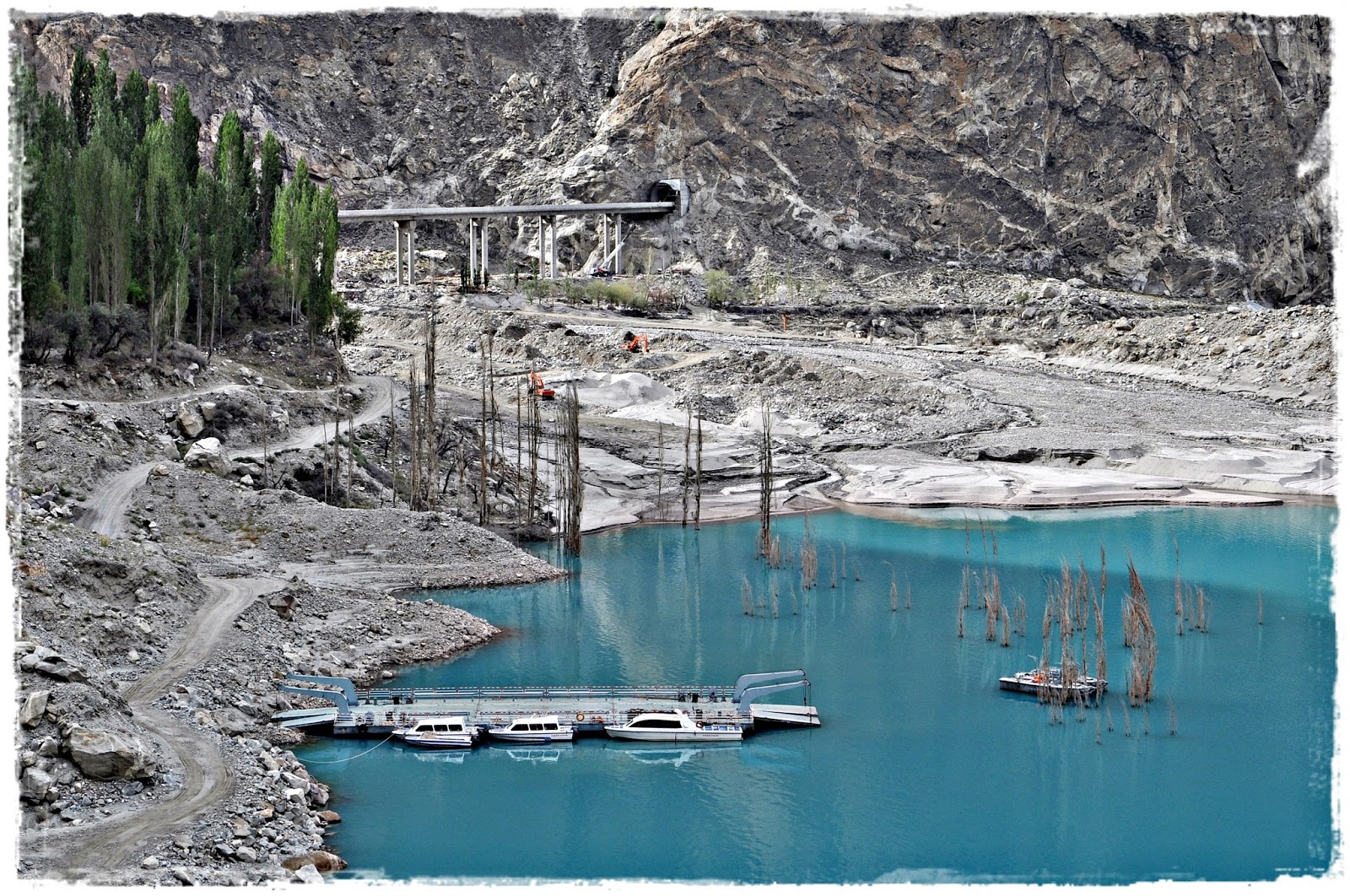
Another 12 km on the Karakoram Highway we arrived at Atta Abad Lake, also known as Gojal Lake. This artificial lake is in the Gojal Valley created in January 2010 due to a massive dam landslide at Attabad village. The landslide killed twenty people and blocked the flow of the Hunza River for five months. The lake flooding has displaced 6,000 people from upstream villages, stranded from land transportation routes. The lake reached 21 km long and over 100 m in depth by the first week when it began flowing over the landslide dam, completely submerging lower Shishkat and partly flooding Gulmit. The residents also had shortages of food and other items due to the blockage of the Karakoram Highway.

(The Pakistan-China Friendship Tunnel)
(Boats terminal to cross the Atta Abad Lake)

Next to the Atta Abad Lake is the Pakistan-China Friendship Tunnel, built by the Chinese from 2012 to 2015 for the alignment of the highway at Atta Abad Lake after the massive landslide. Today we were lucky to be among the first to use the tunnel after its inauguration by the Prime Minister Nawaz Sharif yesterday. The tunnel consists of five tunnels with total length of 7 km, two bridges and 78 culverts.

(The Passu Glacier at the background)
(Rock formations from the snow and ice erosion)

We stopped in Passu, a small village on the Karakoram Highway beside the Hunza River. It lies very near the tongue of the Passu Glacier, and just south of the tongue of the Batura Glacier. The latter is the fifth longest non-polar glacier in the world at 56 km and reaches very near to the highway. After some photo shots and a toilet break at the rest area we continued our journey towards Sost.

We reached Sost early and checked in the PTDC Motel and met with 20 cyclists from the USA who were planning to cross the Pakistan/China border and head to Kashgar.

(Sost town busy with travelers to and from the border)
(Basking in the sun before the journey to Khunjerab Pass)

Sost is a small town in Gojal, Upper Hunza. It is the last town inside Pakistan on the Karakoram Highway before the Chinese border. The town is an important place on the highway for all passenger and cargo transport because all traffic crossing the Pakistan-China border passes through this town. The Pakistani immigration and customs departments are based here. Pakistan and China have opened border for trade and tourism at Khunjerab. The town is connected by the Karakoram Highway to Karimabad, Gilgit and Chilas on the south and the Chinese cities of Tashkurgan, Upal and Kashgar in the north.

(The last check point before the border)
(A snow tiger in captivity at the sanctuary)

After a short rest we boarded the coaster and drove towards the border. I feel relieved to have made it this far but a little apprehensive of the high altitude as we will be crossing the Karakoram mountain range to Khunjerab Pass, at an altitude of 4,693 m. In 2013 some from our group experienced altitude sickness and fainted during our trip from Kashgar to Karakul Lake after a long tiring journey on the Karakoram Highway.

(The majestic Karakoram mountain range)
(Black specks of wild yaks along the highway)
(A group of grazing yak on the mountain slopes)

The Karakoram Highway passes the highest concentration of soaring peaks and glaciers in the world, five of which are over 8,000 m. On the way we stopped at a check-point and Community Conservation Area where we had the opportunity to sight and took a close-up photo shot of a snow leopard and an Ibex. Wild yaks could be seen along with mountain goats on the route to Khunjerab Pass.

(A busy transit point for travelers before crossing the border)
(Mesmerizing mountains, viewed from the highway)

The Khunjerab Pass is the highest paved international border crossing in the world and the highest point on the Karakoram Highway. The roadway across the pass was completed in 1982, and has superseded the unpaved Mintaka and Kilik Passes as the primary passage across the Karakoram Range. On the Pakistani side, the pass is 75 km from Sost. On the Chinese side, the pass is the southwest terminus of China National Highway 314 and is 130 km from Tashkurgan and 420 km from Kashgar. The Chinese port of entry is located 3.5 km along the road from the pass in Tashkurgan County.

(The iconic border archway between Pakistan and China)
(Not that far to Kashgar, China)

The long, relatively flat pass is often snow-covered during the winter season and as a consequence is generally closed from November to May. This is one of the international borders where left-hand traffic in Pakistan changes to right-hand traffic in China and vice-versa

We had our packed lunch at the border while watching the border-crossing activities from a distance. After some photo shots and playing with snow we drove back to Sost. The evening was spent walking from one end of town to the other end with nothing much to see.

(The town is quiet in the evening) 
(A captivating view from our motel room)

We headed to bed early after dinner, worn out from our journey and the excitement of the trip so far.